You might wish to traverse the entire peninsula or simply admire an Area of Outstanding Natural Beauty during a family day out. Either way, Cornwall’s fabulously diverse range of routes will take you everywhere from woodlands and countryside to town and coastline, giving you priority access to some of the most staggering views and lust-have locales the Duchy has to offer.
Wherever you’re staying in Cornwall, there will be a walk nearby to suit, and as the South West Coast Path trails over 300 miles of the entire Cornish coastline - with many beach cafés for a tempting refuel - you’ll never be too far from the famously scenic route. Venture further inland for moorlands, river creek walks, and rural adventures on foot, while a simple stroll around a village or town can present visitors with an equally-as-palpable sense of wonder.
From summer strolls along the rugged coastline to lazy autumn ambles foraging for blackberries and storm-swept hikes across the heath – Cornwall is a walker’s dream destination. We’ve delved into the county’s best circular walks, located in some of the most magnificent areas, to help inspire you to don your walking boots and get exploring...
Whitsand Bay Circular Walk
Distance: 6.5 miles
Difficulty: Moderate

Joining the South West Coast Path at Freathy parking area, head west toward Tregantle Fort and then further inland to Kerslake. Your route may be diverted depending on whether the flags are flying due to live practice taking place at the MoD range at Tregantle. This section will then lead you up a valley, across fields and through woodland toward Crafthole Reservoir. The surrounding wetlands are replete with wildlife, and provide the perfect space to stop-off for a picnic and admire the scenery – or push on toward Portwrinkle for the Finnygook Inn. From here, the path will lead you through the golf course to rejoin the South West Coast Path. Have a break and a cool dip at Finnygook Beach below, or continue back along the path past Kerslake Cliff to rejoin your start route.
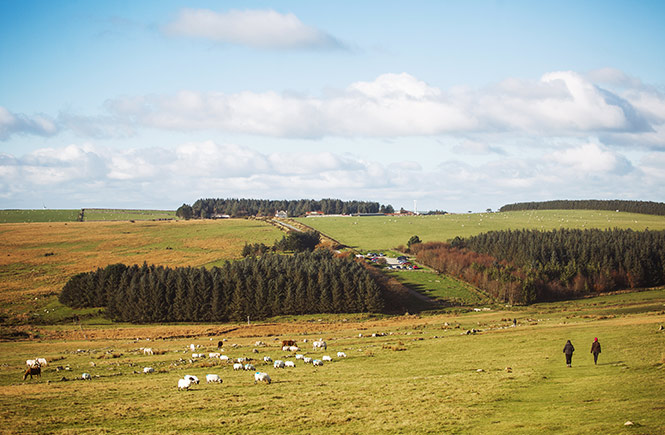
Bodmin Moor Circular Walk
Distance: 7 miles
Difficulty: Moderate/Strenuous
Starting and finishing at the renowned (and dog friendly) Jamaica Inn of Daphne Du Maurier fame (where you can refresh and relax in style), this rugged route explores the moorlands, heaths and prehistoric houses of the heart of Cornwall, taking in a plethora of tors including the county’s highest point, Brown Willy. From the Jamaica Inn, you’ll pass Tolborough Tor and cross over the source of the River Fowey before venturing on to Catshole Tor and the 420m pinnacle of Brown Willy for jaw-dropping and far-reaching views, including St Austell’s china clay territory. The terrain can be challenging at times and rocky underfoot, so exercise caution when ascending and descending the hillsides. The return route skirts Butter’s Tor and passes the open moorland of Priddacombe Downs before returning to the Jamaica Inn.
Bude to Northcott Mouth Circular Walk
Distance: 3.5 miles
Difficulty: Easy
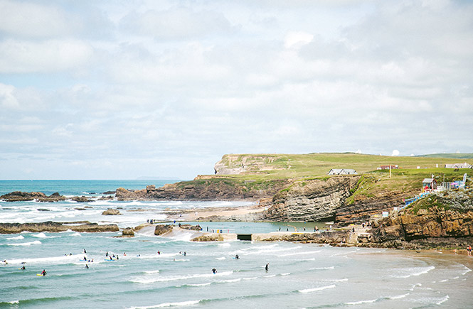
This walk leads you past some of Bude’s must-sees such as Bude Castle and Bude Sea Pool, treating you to sandy beaches and even the River Neet, making it a feast for the eyes while remaining fabulously easy on the feet. Commencing at the Post Office, the route first skirts Bude Castle before leading to Bude Sea Pool (and Summerleaze Beach), so enjoy a laze at either depending on your mood and time schedule. From there, head past the beach huts and Surf Lifesaving Club at Crooklets Beach, then follow the coast path to Northcott Mouth (the southernmost end of the Area of Outstanding Natural Beauty that borders Devon). Chill out on the beach and look for the remains of the SS Belem, which are visible on the low tide at the northern end near Menachurch Point. The return track will take you back via Bude Tunnels, and there’s an array of pubs that you can relax in during the walk including The Carriers Inn, The Barrel, Crooklets Inn and Bencollen Inn.
Zennor Head Circular Walk / Zennor to Gurnard’s Head Circular Walk
Distance: 4.5 miles
Difficulty: Moderate
One of west Penwith’s most ruggedly scenic walks, this is where majestic moorlands and picturesque farmlands meet the Atlantic rollers to spellbinding effect. Follow cliffs and coves to wind your way through the magical landscapes of local lore, passing maritime grasslands, wildflower fields and colourful hedgerows en route. Beginning in the village of Zennor, first make your way to St Senara’s Church to discover the wooden bench depicting the tale of the Mermaid of Zennor before heading to Zennor Cliff and Porthzennor Cove, where you’ll join the South West Coast Path. Spy the offshore island outcrop of The Carracks as you continue past Wicca Pool (where DH Lawrence used to swim) before rounding the headland and venturing inland for the return track through fields and farmsteads (including Tremedda who makes Moomaid of Zennor ice cream), arriving back in Zennor for your favourite tipple at The Tinner’s Arms.
Alternatively, head west for the Zennor to Gurnard’s Head route (of similar distance and difficulty), which will lead you to the coast at Pendour Cove and across the cliffs to Veor and Treen Coves, where you’ll discover an engine house and medieval chapel. Admire the headland before turning inland for The Gurnard’s Head pub and finally, back via the Zennor Churchway path.
Serious walkers could even strike out to the far west and embark upon The Tinner’s Way – an 18-mile ancient circular trail from St Ives to Cape Cornwall that intersects the above section and covers everything from two dozen ancient sites (including numerous engine houses and World Heritage Mining sites) to moorlands, beaches, valleys and Cornish carns.
The Camelford Way Circular Walk
Distance: 1.8 miles
Difficulty: Easy

Explore the pretty market town of Camelford before ambling along the River Camel and admiring the Camel Valley during this uber scenic, easy-going route. Starting down the ‘Riverside walk’ footpath, stroll downstream spotting wagtails and kingfishers before reaching the meadow and path that will lead you to Fenteroon, with views of Camel Valley and the distant hillside of Rough Tor. The path then merges with the road to deliver you back to Camelford, where you can refresh in style at the Darlington Inn or The Masons Arms while pondering your next adventure (that might include a longer 5-mile circular walk from Camelford to Watergate).
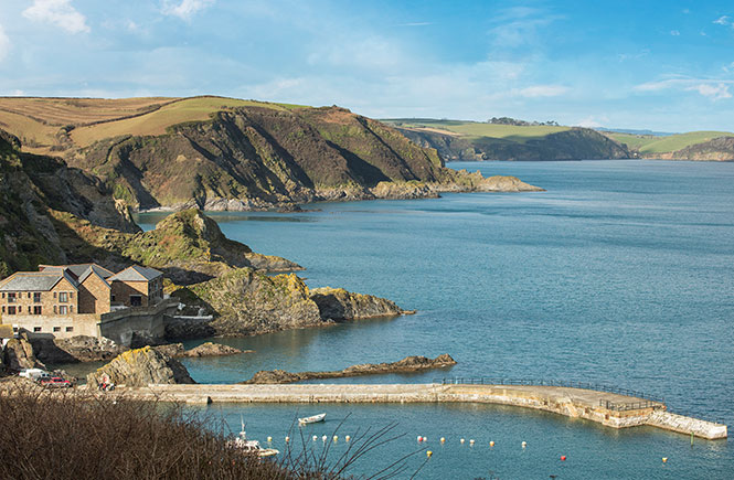
Rame Head Circular Walk
Distance: 5.6 miles
Difficulty: Moderate
A coastal walk through Whitsand Bay that leads to Rame Head and its eerie medieval chapel that also features woodlands, picturesque seaside twin villages and a Napoleonic coastal fort. The first section presents a panoramic feast in the form of Whitsand Bay’s sandy beaches and Plymouth Sound as you weave your way across field and path to Rame Head. From there, the nature reserve of Penlee Point leads to the sandy haven of Cawsand (and neighbouring Kingsand), so take the time to kick back on the beach or in a cafe while absorbing the atmosphere before making your way back.
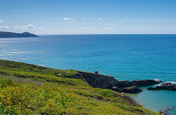
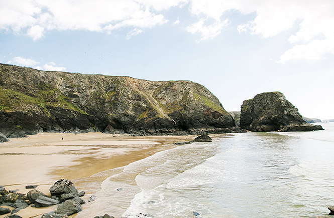
Hell’s Mouth to Godrevy Circular Walk
Distance: 5 miles
Difficulty: Moderate
Hike the high hills at Hell’s Mouth and cross the heathland reserve of The Knavocks before being awed by the seal colony at Mutton Cove during this stunning walk on the coastal wild side. Starting at the Hell’s Mouth lay-by (near the café), head to the coast path for dizzying views of the dramatic clifflines and smugglers’ cove below. From here, the route takes you to Fishing Cove (with a tricky steep path for access onto the beach) toward the headland through Navax Point’s heathland: home to a diverse range of birds and butterflies. Continue along the coast path to Mutton Cove (do not disturb the seals) and Godrevy Point for jaw-dropping views of the lighthouse and St Ives Bay. Now is the perfect time to hit the golden sands of Godrevy, amble along the beach to neighbouring Gwithian - or simply stop for refreshments at The Rockpool or Godrevy Beach Café before continuing the return route inland past fields, the stream and marshes to Hell’s Mouth Café.
For a shorter, and fantastically accessible circular walk, start and finish at Godrevy and walk around Godrevy Head. Dramatic views and wildlife watching ensure this wheel-friendly walk packs a visual punch!
Gorran Haven Circular Walk
Distance: 5 miles
Difficulty: Moderate
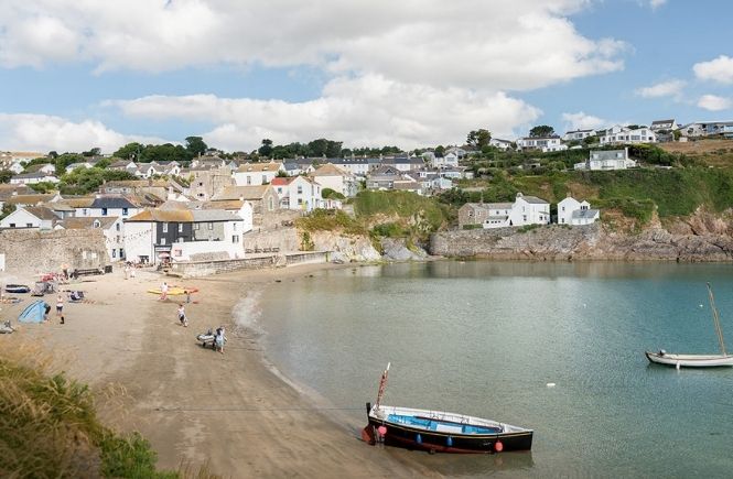
Beginning at the pretty fishing village of Gorran Haven, stroll along the South West Coast Path around Pen-a-Maen to the beautiful Vault Beach (you'll find many beautiful Mevagissey beaches on this walk). If you can bear to drag yourself away and back on foot, the coastal path continues to Dodman Point (the highest headland on Cornwall’s south coast) and on to the stunning stretch of Hemmick Beach. The inland footpath passes farms and cottages to take you back to Gorran Haven, where you can refuel where you started in scenic style at the Coast Path Cafe.
Tintagel Circular Walk
Distance: 2.5 miles
Difficulty: Easy
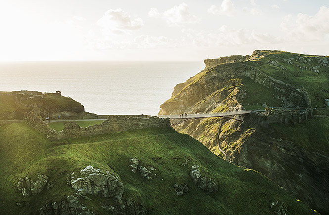
This short stroll through north Cornwall’s popular destination takes in a trio of Tintagel’s historic sites by rounding King Arthur’s Castle and Merlin’s Cave, the Old Post Office, and the ancient cliff church. Starting at Tintagel Visitor Centre, the route passes King Arthur’s Great Halls and the 14th century Old Post Office before taking you to the rocky headland of Barras Nose, complete with stunning sea and castle views. The coast path continues to Castle Beach, where you’ll find a beautiful waterfall alongside Merlin’s Cave, which you can walk under to West Cove on a low tide. Take the time to explore the 13th century castle in all its historic glory before heading toward Glebe Cliff for the church of St Materiana and the war memorial. The lane beyond will take you downhill to the old vicarage, after which you’ll cross several fields and a track that will deliver you back to the Visitor Centre. With an assortment of pubs en route including The Cornishman, The King Arthur’s Arms, Ye Olde Malthouse and Wotons Inn, along with various cafes and shops, this walk is an especially family-friendly choice (though might be rocky underfoot and features a few steeper sections).
Should you wish to explore further, then there are a series of adjoining walks, including the popular Tintagel to Rocky Valley circular route (an easy-moderate 4 mile walk). At Barras Nose, it continues past the Iron Age hillfort at Willapark to Bossiney Haven’s beautiful sandy beach, on to Benoath Cove and then through the gorgeous woodland around the Rocky Valley river (and back to Tintagel via Bossiney).
Pentewan, Heligan and Mevagissey Circular Walk
Distance: 5.3 miles
Difficulty: Moderate-strenuous
Offering plenty of facilities along with some seriously swoon-worthy landscapes, this walk will beguile everyone who embarks upon it. Combining one of the county’s most breath-taking gardens with the famous South West Coast Path, you’ll encounter gorgeous green spaces, stunning sandy beaches and a pretty fishing village all along one mesmerising route. From Pentewan’s central car park, you’ll traverse field, woodland, riverside rail trail, and country lanes to reach the botanical beauty of The Lost Gardens of Heligan. A visit here is a must-do, and after you extract yourself from the glorious realms of the 19th century garden, the route will lead you south toward a forested valley and on to the achingly picturesque, Mevagissey. Find your way back to Pentewan via the South West Coast Path, and settle into a pub or two en route courtesy of The Ship Inn, The Sharksfin, The Kings Arms and The Fountain Inn.
Pentire Steps and Park Head Circular Walk
Distance: 2 miles
Difficulty: Easy
For a leisurely coastal walk packed with stunning seascapes and teeming with birdlife including kestrels and skylarks, this route just outside Newquay is a particularly enchanting choice. Taking the coast path to the cove of Porth Maer, which is a great spot for rock pooling at low tide, continue along as far as the headland for fabulous views of Trescore Islands (which features a lagoon and sandy beach between the islets at low tide), and further on to Park Head and the remains of an Iron Age hillfort. The cliffs overlook Pentire Steps Beach, and from here you can make your way toward Bedruthan Steps to take in the staggering sea stacks in all their glory, or embark upon the return route through pretty fields filled with wildflowers.
Cotehele Circular Walk
Distance: 1.7 miles
Difficulty: Easy

Explore the National Trust’s historic gem of Cotehele with a supremely easy walk around this extraordinary estate on the banks of the River Tamar. Start at the Edgcumbe tearoom at Cotehele Quay and follow the trail into woodland, where you can take a detour to visit either the weir or Cotehele Mill. Continue to Cotehele House and Gardens, then downhill for Calstock lookout and the beautifully quaint, Chapel-In-The-Wood. Bypass fields and woods to return to Cotehele Quay car park.
Ready to book your walking holiday to Cornwall? Check out our stunning range of cottages here.
Tags: Walking